Louisiana Purchase
In United States history there have been many moments when history could have changed completely. One of these is the Louisiana Purchase. In 1803 Napoleon Bonaparte after losing to the Haitian rebellion at the French Colonies in Haiti, Napoleon was in desperate need of funds to fuel his conquest in Europe. He decided to sell French land in the new world to get the money he needed. After talking to his council he considered selling it to either neighbor of New France in the new world, the United States or the Spanish Crown. Napoleon was determined to have to negotiate with his fellow council about selling the land however when the expressed approval of his plans he considered the prospects more clearly. More money could be made by selling halve of the land to both the United States and Spain than selling the whole to either one. This then split the entirety of the territory of Louisiana and quickly lead to US and Spanish conflict. While Napoleons efforts were futile as his war machine eventually failed in the end Spain and the US went to war for years after fighting over the smallest amount of land between them.
Map of Territories
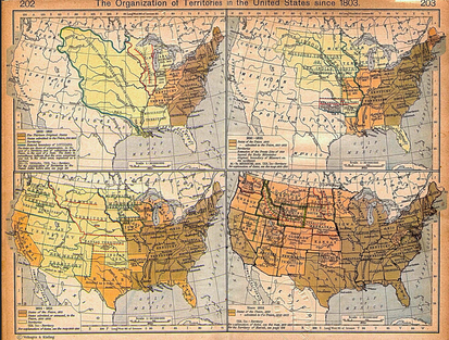
To the left is a collection of maps from 1803 to 1850. The First map is on the top left shows a section of North America at the time of the Louisianan Purchase. The United States are on the right and on the left is Spanish Territory. In the middle on the bright yellow section is the Louisianan Purchase. One can see the vast amount of area that the Louisiana Purchase was. Each map after that is a guess to what would have happened had the United States been the lone buyer of the Louisiana Territory. The creator of these maps is unknown however they are outstandingly accurate for a primary artifact of that time.
Treaty
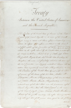
To the right is one of the most essential parts of the collection. It is an original treaty between the French Government and the United States Government. It specified the terms and conditions at which the Louisiana purchase would be sold to the US. Keep in mind that this was written in the case that the French Republic sold the territory to only America at the price of 11.25 million dollars. This treaty is organized In articles signed in Paris by Grand Officer of the French Court François Barbé-Marbois, US politician Jas. Monroe and Founding Father of the States, Robert R Livingstone. A transcript can be found on Ourdocuments.gov and can be accessed by clicking here.
One Important Section from the First Article that fully represents the transaction is as follows.
"And whereas in pursuance of the Treaty and particularly of the third article the French Republic has an incontestible title to the domain and to the possession of the said Territory--The First Consul of the French Republic desiring to give to the United States a strong proof of his friendship doth hereby cede to the United States in the name of the French Republic for ever and in full Sovereignty the said territory with all its rights and appurtenances as fully and in the Same manner as they have been acquired by the French Republic in virtue of the above mentioned Treaty concluded with his Catholic Majesty."
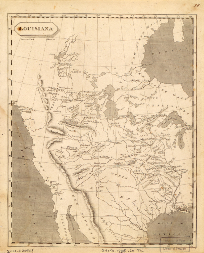
Water Ways
Below is one of our largest maps of the great territory of Louisiana. It was drawn by S Lewis (name right below the title in the left hand corner) in 1805. Take notice of the water ways drawn in the map. Much of the war between Spain and American is focused near New Orleans. This is because that coastal city controls everyone of those water ways in at least one way. In the current state of Louisiana, New Orleans controls the mouth of the river that controls which boats can make their way through the North American continent all the way up to Canada.